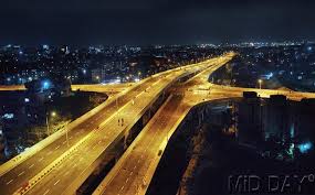
The Santa Cruz – Chembur Link Road , shortened to SCLR, is a 6.45 km long arterial road in Mumbai, connecting the Western Express Highway (WEH) in Santa Cruz with the Eastern Express Highway (EEH ) in Chembur. It contains India's first double-decker flyover. The six-lane road was constructed as part

of the World Bank-funded Mumbai Urban Transport Project (MUTP) at a cost of 454 crore (US$76 million) . The World Bank withdrew funding midway through the project due to repeated delays, and the second phase was financed by the Mumbai Metropolitan Region Development Authority (MMRDA) with its own funds.
Although the groundwork for the link road was originally planned to commence in September 2003, it began only in 2007. The SCLR was severely delayed, taking more than 11 years for the work to be completed. The project missed 12 deadlines since the original deadline of November 2004. The delay in the project was primarily due to rehabilitation and resettlement related works. The SCLR was termed an "engineering marvel" by the National Geographic Society, and was described by the World Bank as the "world's most delayed road project".
A portion of the SCLR, the 560 m Kurla–Kalina flyover over LBS Marg, was opened to the public on 10 August 2012. The SCLR was opened to the public on 18 April 2014. The maximum speed limit for all vehicles is 30 kilometres per hour (19 mph) Halting or parking of vehicles on the entire stretch of SCLR is prohibited. Entry is prohibited for pedestrians, heavy vehicles (except any bus carrying passengers), all types of bicycles, tricycles and auto tricycles used by the disabled, all types of animal carts and hand-pulled carts.
History
Background
In 2002, the Government of Maharashtra, the Indian Railways and the MMRDA , with financial assistance from the World Bank, decided to undertake
the Mumbai Urban Transport Project (MUTP) to find a long term solution to city's transport and communication issues. Mumbai, being a vertical city geographically, has resulted in rail and road connectivity being concentrated along the north-south route. After a population explosion and subsequent growth of the suburbs, the authorities realised that the city's east-west connectivity had been mostly ignored with weak road links and only a handful of bridges to cross over the rail lines. The MUTP identified a number of subprojects to strengthen the suburban rail and road transport in Greater Mumbai and the Mumbai Metropolitan Region (MMR) as a whole. As a part of the MUTP , the Maharashtra State Development Corporation (MSRDC) and the BMC undertook the construction of the Santacruz – Chembur Link Road (SCLR) linking the Western Express Highway (WEH) and the Eastern Express Highway (EEH). The SCLR, along with the widening and improvement of the Jogeshwari – Vikhroli Link Road (JVLR), was one of two east-west road corridor projects implemented under the first phase of the MUTP, and were intended to ease commutation problems and act as links between Mumbai's Eastern and Western Suburbs.
Prior to the SCLR's opening, commuters traveling from the Western Suburbs towards the Eastern Suburbs or Navi Mumbai had to take the JVLR , the Andheri-Kurla Road or a detour from Sion to reach Chembur. During peak hours, this would take 90 minutes to 2 hours. After the SCLR opened, travel time between Santacruz and Chembur reduced to 17 minutes. The SCLR will be an important arterial road connecting the Western Express Highway and the Eastern Express Highway . The SCLR is expected to significantly decongest the EEH and the WEH , and ease traffic congestion at the Amar Mahal Junction, Vakola , Kalanagar Junction, Sion and Kurla . It will also decrease traffic congestion on roads in Santacruz , Kalanagar , Dharavi , Sion and Chembur . The Times of India reported that commuters can save 50-60 on autorickshaw and taxi fares (at April 2014 rates) when traveling between the Eastern and Western Suburbs via the SCLR. Prior to its opening commuters would have had to take a longer route via Dharavi and Sion . A commuter going to Vakola in the western suburb of Santa Cruz from the eastern suburb of Mulund via the earlier route, would have to travel a distance of least 23 km. The SCLR would reduce the distance by 4-5 km and time by 30 minutes.
Land acquisition and rehabilitation
Therefore, after the revision of the BSES of December 2004, a total of 3167 structures would be impacted – 2575 residential, 540 commercial, 33
residential-cum-commercial, and 19 community/religious structures. As of 30 April 2006, a total of 2591 structures had been resettled – 2418 residential, 145 commercial, 26 residential-cum-commercial, and 2 religious/community structures. Apart from this, an additional 754 structures will be affected by the final alignment for a 45.7 metre width road. This includes 492 tenements of 20 MHADA buildings and 262 encroached slums in the areas of Sable Nagar, Shanta Jog Marg, Rahul Nagar and Nehru Nagar. Taking all the PAHs into account, the a total of 3921 structures were impacted by the project (Residential-3329, Commercial-540, Residential-plus-commercial-33, community structures-10, religious structures-9).
Construction
The SCLR was commissioned in 2003 under the World Bank-funded MUTP, and was originally scheduled to be completed by November 2004. The SCLR and JVLR projects were initially entrusted to the Public Works Department (PWD) for implementation as per World Bank guidelines. Later on, these works
were entrusted to the Maharashtra State Road Development Corporation (MSRDC) for implementation as per World Bank guidelines, and the Mumbai Metropolitan Region Development Authority (MMRDA) was appointed as the nodal agency. The SCLR project was implemented in two phases. The first phase was executed by the MSRDC and the second phase was executed by the Brihanmumbai Municipal Corporation (BMC). Phase I comprises the 3.45 km long section from the east end of the 6-lane Mithi River Bridge up to the Amar Mahal Junction of the Eastern Express Highway . Phase II consists of the 3 km section from the WEH to the Mithi River . Phase I was funded by the World Bank, while Phase II was financed by the MMRDA with its own funds.
Phase I of the project consists of widening of existing road from Mithi River up to LBS Road (0.650 km), construction of flyover (0.250 km), construction of new link (1.706 km) and a ROB (0.420 km) over Central Railway tracks at northern Kurla . Out of the 3.45 km of Phase I, about 1 km runs on existing alignment and the remaining 2.45 km is virgin/new alignment. Phase I was divided into two sections for execution purpose. Section 1 of Phase I consists of two non-contiguous portions: from Mithi River to Middle Income Group (MIG) area (1.3 km); and from MHADA to Amar Mahal Junction (0.6 km). The 1.40 km Section 2 consists of the RoB and viaduct portion from Ch. 1+335 to Ch. 2+775, including the Nehru Nagar Arm . Section 2 of Phase I lies between the two parts of Section I, within the overall 3.45 km length. Section 1 and 2 were contracted to Patel Engineering Ltd and Gammon India Ltd. respectively. The Louis Berger Group Inc. served as Project Management Consultants for both sections. The civil works contract for Section 1 was signed on 29 September 2003, and awarded for an amount under NCB of 33.81 crore (US$7.514 million).
The scope of work undertaken as a part of Section 1 and 2 is listed below:
- Section 1
- Construction of 6-lane concrete road with 3 m wide foot path on either side with central divider
- Construction of 6-lane, 527 m long flyover across LBS Marg junction, with 7.5 m wide service road and 3 m wide foot path on either side at grade

- Replacement of existing steel bridge on old Agra Road with new one (all on Santacruz side i.e. from Ch. 0+000 to 1+335– East end of Mithi River Bridge to start of ramp of ROB across Central Railway tracks)
- Road from Ch. 2 + 775 to 3 + 400 (from end of ramp of viaduct to Amar Mahal junction on EEH ) on Amar Mahal side
- Construction of one vehicular Subway near Amar Mahal junction, construction of junctions at Amar Mahal (at grade) with EEH and S.G.Barve Marg
- Improvement of junctions on surrounding road network
- The work also involves shifting and relocation of underground and over ground utility services like water mains, electric cables, telephone lines, TATA H.T Pylon etc.
- Section 2
- Long viaduct with solid ramp in Reinforced Earth wall (R.E.wall) for 350 metres on Santacruz side
- Road Over Bridge (ROB) across Central Line at first floor level and further two level viaduct close to Lokmanya Tilak Terminus.
- Solid ramp in R.E.wall for 363 metres at first floor level and for 456 metres at second floor level
- Short viaduct – cum – ROB on harbour line of Central Railway with a junction to main viaduct at first floor level for access to Nehru Nagar through the property of Kurla Dairy and Lokmanya Tilak Terminus Arm as approach to Lokmanya Tilak Terminus .
- Solid ramp R.E.wall for 104 metres for Nehru Nagar arm (Total length of ROB and viaduct including ramps is 1.40 km).
A portion of the SCLR, the 560 m Kurla-Kalina flyover over LBS Marg, was opened to the public on 10 August 2012.
On 24 March 2014 , construction work on the SCLR was complete on the sections from the Mithi river to Ghazinagar , Kurla (W) , and from Ghazinagar , Kurla (W) toRahul Nagar , Tilak Nagar . However, the section from Rahul Nagar to Eastern Express Highway via Amar Mahal flyover was incomplete. MMRDA Executive Engineer M.A. Wani, in his reply to the RTI, stated that the construction of steel members of an S-shaped girder at the fag end of the SCLR near the Amar Mahal flyover was incomplete. The MMRDA admitted that it had changed the specification of the girder, and decided to have the S-shaped girder in steel rather than in concrete. The work was expected to be ready by 31 January 2014. The decision was approved by executive committee of MMRDA in its meeting held on 11 January 2012.
The SCLR was inaugurated by MMRDA officials at 8:15am on 18 April 2014, by breaking 11 coconuts (the project had been delayed by 11 years) and burning incense sticks. Unlike most projects in India, the SCLR was opened without fanfare, and no politicians were present at the opening, as the code of conduct for the 2014 general elections was in force at the time. The MMRDA quickly completed the ceremony and opened the road to traffic. Even as the SCLR was being inaugurated, workers were still giving finishing touches such as laying tiles on the pavement and fixing up the shoulders of the road beneath the flyover portion at Tilak Nagar and Halav Pul. Motorists complained about dust in the air near Tilak Nagar, as the workers had not swept the cement from the surface. Traffic was sparse on opening day, which officials believe was because it was a public holiday due to Good Friday. Several motorists were reportedly seen asking for directions, which the Mumbai Traffic Police blamed on inadequate signage directing towards the SCLR.
Delay
Although, the groundwork for the link road was originally planned to commence in September 2003, it began only in 2007. The SCLR was severely delayed, taking more than 11 years for the work to be completed. The project missed 12 deadlines since the original deadline of November 2004. Following this, 11 other deadlines have been fixed and missed for the project – September 2006, December 2008, December 2009, June 2010, June and December 2011, December 2012, March 2013, October 2013, December 2013 and 31 March 2014. The delay in the project was primarily due to rehabilitation and resettlement related works. Around 3,500 people, as well as residents of 350 MHADA tenements, who were displaced by the SCLR were rehabilitated.
A major delay occurred in getting clearance from Central Railway (CR) to construct a 50.9-metre bridge over the Central Line. Despite receiving the request in 2007, CR took 5 years and asked for 4 changes in design before finally approving construction in July 2012. The approval came with the rider that MMRDA could only start construction in October 2012, after the monsoon. A railway official defended CR stating, "MMRDA blamed us for the delay. But the design of the road overbridge across the tracks was such that it would not have got the commissioner of railway safety's approval. The consultants should have thought about this long ago. We had also given blanket approval to launch girders more than a year ago. But the girder-launching work was carried out six months ago as they did not arrive from Punjab at the site, where, too, no preparations were made." The MMRDA also faced challenges launching the 14 girders, each weighing 140 tonne, as they could only carry out work for 3 hours at night to avoid affecting rail traffic. All girders were launched in 21 days.
Other work
In September 2013, the MMRDA invited agencies to prepare a Detailed Project Report (DPR) for three proposed bridges to complement and regulate the flow of traffic from the SCLR. The first flyover is planned from Bandra-Kurla Link Road to CST Junction in Kurla, and the second will be from Mumbai University junction in Kalina to CST Road. The bridges were not part of the original plan of the SCLR, but the MMRDA felt that the traffic congestion on CST Road would increase once the SCLR was completed, and that the flyovers were required to regulate traffic and provide direct connectivity from BKC to SCLR.The third DPR concerns the remodelling of the existing CST Bridge. After remodelling, the 40m long and 30m wide bridge would be 100m long and will 45m wide.
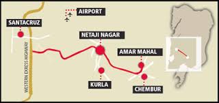
Route
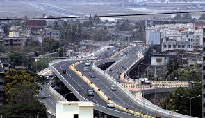
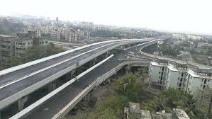
The SCLR is 6.45 km long and 45.7 metres wide. The SCLR has a total of three flyovers on its route, namely, CST Road flyover (the main flyover spanning a total length of 3.45 km), the 560 metre Kurla-Kalina flyover above LBS Marg and the double-decker flyover (combined length of 1.8 km) crossing over the
Route Map
Central and Harbour Line tracks at Tilak Nagar, The SCLR also has two arms – one for Lokmaniya Tilak Terminus and the other one for Kurla Dairy. The 1096 metre long Amar Mahal junction flyover connects the SCLR with the EEH. The flyover is 17 metres wide. The S-shaped steel girder is 92 metres long and 8.5 metres in width, and its actual cost is 59.51-76.41 crore.
There are a total of six-seven signals on the entire road, which were installed based on the suggestions of the Mumbai Traffic Police. The maximum speed limit for all vehicles is 30 km/h on all bridges of the SCLR. Halting or parking of vehicles on the entire stretch of SCLR is prohibited. Entry is prohibited for pedestrians, heavy vehicles (except any bus carrying passengers), all types of bicycles, tricycles and auto tricycles used by the disabled, all types of animal carts and hand-pulled cards on the SCLR from Chedda nagar, Mother Dairy at Nehru Nagar in Kurla (East), Lokmanya Tilak Terminus as well as from sleep roads connecting the SCLR to Amar Mahal junction and Shanta Jog Marg.
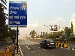
The SCLR begins at Dr. Hans Bhugra junction on the Western Express Highway in Santacruz (East), and runs to the east skirting the Vidyanagari Campus (University of Mumbai at Kalina ) on its south. It then crosses the bridge over the Mithi River on CST road, and the alignment follows CST road up to the junction at LBS Marg. The road then follows S.G. Barve Marg up to 100 metres west of the steel bridge on the old Mumbai Agra road. Thereafter the alignment deviates towards the left side near Buddha Mandir. It runs over a new alignment to cross the Central Line about 1 km north of Kurla railway station over a viaduct (RoB), and passes adjacent to the south-west end of Lokmanya Tilak Terminus (LTT). After crossing Lokmanya Tilak Terminus, the SCLR runs parallel to the Harbour Line before meeting the EEH at the Amar Mahal junction in Chembur. From LTT, the SCLR passes between the MHADA quarters and crosses the Tansa pipeline beyond Tilak Nagar railway station. After crossing the pipeline, the alignment splits into 3 arms - 2 arms on the north side of the EEH and 1 arm on south side adjacent to the Chembur flyover - forming a double decker flyover. The top deck of the four-armed flyover is dedicated to traffic between the EEH at Amar Mahal junction and the WEH at Vakola junction via Kurla and Kalina . The lower deck is for vehicles going to LTT , Kurla Dairy (towards Chunabhatti , Suman Nagar ) besides Amar Mahal and Vakola . The elevated arm towards WEH via Kurla crosses the Central Line while the arm towards Kurla Dairy crosses the Harbour Line at LTT. Commuters can take the Vakola junction road to reach the upper level of the double-decker flyover to reach the EEH directly with the help of Amar Mahal Junction flyover. They can take the lower level of the flyover and turn right to reach Kurla railway station or turn left to reach the Lokmanya Tilak Terminus. The lower level flyover also has footpaths for commuters to cross over from Kurla station to Lokmanya Tilak Terminus and vice versa. The road terminates at the Amar Mahal junction.
Alignment of Nehru Nagar – LTT link road
The total length of this alignment is about 1.2 km. It starts from S.G. Barve Marg (East) at a junction located about 100 m away from Kurla railway station (East). It overlaps with the existing 4-lane Kurla Dairy road up to the dairy entrance (Km 0+360). It traverses through dairy vacant premises for about 300 m cross Kurla-Panvel Harbour Line at Km 0+660 and joins the SCLR at Km 0+825 in front of LTT and further runs on the Ghatkopar – Amar Mahal Junction Road to provide access to Kurla Terminus. The overlapping length of this link road on the Ghatkopar – Amar Mahal Junction Road is about 375 m (1+200 minus 0+825). The junction of the SCLR and this alignment at Km 0+825 is at an elevated level providing a vertical clearance of about 6.525 m from the ground.
| Stretch | Length (km) | Details of existing road | Details of road constructed for SCLR |
|---|---|---|---|
| Phase I (3.45 km section from Mithi River to EEH) | |||
| Mithi River – LBS Marg | 0.650 | 4-lane concrete road | 10-lane concrete road + Flyover + Slip roads |
| LBS Marg – Old Agra road | 0.250 | 4-lane (intermediate) concrete | Flyover + slip roads (4 Lane + 6 Lane) |
| Old Agra road – Buddha Colony | 0.205 | 2-lane concrete road | 10 lane concrete + replacement of existing steel bridge |
| Buddha Colony – LTT | 1.095 | Virgin Land | 6 lane concrete road + 6 lane RoB + Viaduct |
| LTT – Tansa Pipeline | 0.300 | 2-lane road | Viaduct |
| Tansa pipeline – Rahul Nagar | 0.650 | Virgin Land | Viaduct + 6 lane concrete road |
| Rahul Nagar – Amar Mahal junction | 0.300 | One side carriageway | 10-lane split carriageway |
| LTT Arm | |||
| S.G. Barve Marg junction – Kurla Dairy | 0.380 | 4 lane road | 4lane + footpath + median |
| Kurla dairy – LTT junction | 0.420 | Virgin land | 4 lane ROB + approaches |
| Phase II (3 km section from the WEH to the Mithi River) | |||
Junctions
There are four important road junctions on the corridor viz. LBS Marg junction, S.G. Barve Marg (West) junction, LTT junction and Amar Mahal junction.[12]
- LBS Marg Junction
The LBS Marg junction is 4-legged. CST road from university side and S. G. Barve Marg from Kurla Station (W) side joins LBS Marg at Chainage 0+650. Both CST and S.G. Barve roads which form part of SCLR are concrete roads. CST road is a 4-lane divided carriageway and S.G.Barve road is a 2-lane single carriageway except at junction portion for about 150–200 m length from the junction towards Kurla side. The traffic on CST and S.G. Barve road is mainly inter-city and intersects with a mixture of through and inter-city traffic on LBS Marg. The SCLR after its construction is expected to significantly contribute to traffic inflow into junction and which will cause traffic delays. To ease off this congested traffic delays and to facilitate through and hindrance free movement, the 560 metre Kurla-Kalina flyover was constructed with service roads at this junction. The LBS Marg flyover was opened in August 2012.
- S.G. Barve Marg (W) Junction
The location of this proposed junction on SCLR is at Chainage 1+000 where the 6-lane SCLR deviates from S.G. Barve Marg (W) to traverse on its own virgin alignment forming a 3 legged junction. Presently S.G. Barve Marg is 2-lane concrete road at this location. This junction will facilitate traffic exchange from Kurla (W) to SCLR and will help to share the traffic load at LBS Junction.
- LTT Junction
The proposed Nehru Nagar link from Kurla (E) forms this junction with SCLR in front of L.T. Terminus at Chainage 2+200. Presently, the approaches of main line ROB of SCLR and Harbour Line RoB of Nehru Nagar link join at an elevation of about 4.5m above ground to form this Junction. The proximity of the Harbour lLine (about 120 m) and future expansion in front of LTT yard does not allow this proposed junction formation on ground. This junction will mainly serve the terminus bound traffic from SCLR and Kurla East.
- Amar Mahal Junction
The SCLR terminates at the 4-legged Amar Mahal junction. This junction connects 5 major roads with the Eastern Express Highway and heavy traffic flow is witnessed through the area every day. The Amar Mahal junction is formed by the roads coming from Ghatkopar, R.C. Marg in Chembur, and the EEH in Thane and Sion. To facilitate exchange of traffic between SCLR and the aforementioned roads at the junction, the 6 lane SCLR splits into two parts before meeting Amar Mahal Junction. The 3-lane left carriageway meant for SCLR traffic outflow meets Ghatkopar road on west side of EEH. The 3-lane right carriageway meant for SCLR traffic inflow again shifts of which 2 lanes pass through existing subway of EEH and one lane on regraded down ramp of EEH. The disturbed down ramp of EEH goes above this 1-lane of right carriageway and runs along with it to the end at Ghatkopar road.