(Adding categories) |
No edit summary |
||
| (2 intermediate revisions by the same user not shown) | |||
| Line 1: | Line 1: | ||
| ⚫ | [[File:Pmc1.jpg|thumb|250px]]<p style="line-height:19.1875px;color:rgb(0,0,0);font-family:sans-serif;">'''Kurla''' is a suburb of Mumbai, India. It belongs to Zone 5, Ward 'L' of the Municipal Corporation of Greater Mumbai and lies immediately north of Mumbai city limits. It's railway station is one the busiest on the Mumbai suburban railway on the central and harbour railway lines of Mumbai as is the Lokmanya Tilak Terminus (LTT) for out-station passenger/express trains.</p> |
||
| − | |||
| + | ==History== |
||
| − | |||
| − | |||
| ⚫ | |||
| ⚫ | |||
| − | ==<span class="editsection" style="-webkit-user-select:none;float:right;margin-left:5px;">[[http://en.wikipedia.org/w/index.php?title=Kurla&action=edit§ion=1 edit]]</span>History== |
||
| − | |||
| − | [[File:220px-Holy_Cross_Church_Kurla_full.jpg|thumb]] |
||
| − | [http://en.wikipedia.org/wiki/File:Holy_Cross_Church_Kurla_full.jpg ]Holy Cross Church was built during the Portuguese era<p style="line-height:19.1875px;color:rgb(0,0,0);font-family:sans-serif;">In 1548, The village of Kurla along with six others was given by the Governor of [http://en.wikipedia.org/wiki/Portuguese_India Portuguese India] to [http://en.wikipedia.org/wiki/Antonio_Pessoa Antonio Pessoa] as a reward for his military services.<sup class="reference" id="cite_ref-1" style="line-height:1em;">[http://en.wikipedia.org/wiki/Kurla#cite_note-1 [1]]</sup> In 1668, Kurla was part of the islands leased out to the British East India Company. At this time, Kurla was connected to [http://en.wikipedia.org/wiki/Sion,_Mumbai Sion] by [http://en.wikipedia.org/wiki/Sion_Causeway Sion Causeway].</p> |
||
<p style="margin-top:0.4em;margin-bottom:0.5em;line-height:19.1875px;color:rgb(0,0,0);font-family:sans-serif;">The name Kurla originated from "Kurli", the local name for crab, (as these were found in plenty in marshes in the vicinity) before it became a sub-urban locality.</p> |
<p style="margin-top:0.4em;margin-bottom:0.5em;line-height:19.1875px;color:rgb(0,0,0);font-family:sans-serif;">The name Kurla originated from "Kurli", the local name for crab, (as these were found in plenty in marshes in the vicinity) before it became a sub-urban locality.</p> |
||
| − | <p style="margin-top:0.4em;margin-bottom:0.5em;line-height:19.1875px;color:rgb(0,0,0);font-family:sans-serif;">Coorla, as it was spelt during the British Raj, was a major station on the [http://en.wikipedia.org/wiki/Great_Indian_Peninsula_Railway Great Indian Peninsula Railway] ten miles north-east of Bombay, and with six other villages, Mohili, Kolikalyan, |
+ | <p style="margin-top:0.4em;margin-bottom:0.5em;line-height:19.1875px;color:rgb(0,0,0);font-family:sans-serif;">Coorla, as it was spelt during the British Raj, was a major station on the [http://en.wikipedia.org/wiki/Great_Indian_Peninsula_Railway Great Indian Peninsula Railway] ten miles north-east of Bombay, and with six other villages, Mohili, Kolikalyan, Marol, Shahar, Asalphe, and Parjapur, was the property of Mr. Ardeshir Hormasji Wadia, a Parsi merchant of Bombay, who paid for them a yearly quit-rent of £358 (Rs. 3587). The villages were originally (in 1808) given to Mr. Hormasji Bamanji Wadia in exchange for a piece of land near the Apollo pier gate in Bombay. The difference between the value of the villages and of the ground in Bombay, £864 (Rs. 8640), was at first paid yearly to Government. It was redeemed and the estate conveyed in fee simple in 1840–41. Kurla had two cotton mills, one of them, the Dharamsi Punjabhai being the largest cotton spinning and weaving mill in the Presidency, with 92,094 spindles and 1280 looms. The other was the Kurla Spinning and Weaving Mill . The village had a population of 9715, about half of them mill-hands, the rest – chiefly fishermen, husbandmen and salt-makers. The [http://en.wikipedia.org/wiki/Holy_Cross_Church,_Kurla Holy Cross Church] at Kurla, built during the Portuguese rule and rebuilt in 1848, is one of the oldest churches in Mumbai.</p> |
<p style="margin-top:0.4em;margin-bottom:0.5em;line-height:19.1875px;color:rgb(0,0,0);font-family:sans-serif;">The Mithibai Hormasji Wadia Dispensary was built by Mr. Bamanji Hormasji Wadia in 1855, and endowed by him with £1200 (Rs. 12,000). It was in charge of an assistant surgeon, and, in 1880–81, had an attendance of 7367 out-patients. The salt pans covered an area of about 66 acres (270,000 m<sup style="line-height:1em;">2</sup>) and yielded a yearly revenue of £3418 (Rs. 34,180). There was also a considerable manufacture of shell lime. Kurla was connected with Sion on Bombay island by the Sion causeway, which bore the following inscription: ' This causeway was begun in May 1798 and was finished in January 1805, during the administration of the Honourable Jonathan Duncan Esquire. It cost £5037 (Rs. 50,374). It was doubled in width, and other improvements added, in 1826, under the government of the Honourable Mountstuart Elphinstone, at a further cost of £4000 (Rs. 40,000). The causeway was originally constructed under the superintendence of Captain William Brooks of the Engineers, and the additions and improvements made in 1826 under that of Captain William Tate of the same corps.'</p> |
<p style="margin-top:0.4em;margin-bottom:0.5em;line-height:19.1875px;color:rgb(0,0,0);font-family:sans-serif;">The Mithibai Hormasji Wadia Dispensary was built by Mr. Bamanji Hormasji Wadia in 1855, and endowed by him with £1200 (Rs. 12,000). It was in charge of an assistant surgeon, and, in 1880–81, had an attendance of 7367 out-patients. The salt pans covered an area of about 66 acres (270,000 m<sup style="line-height:1em;">2</sup>) and yielded a yearly revenue of £3418 (Rs. 34,180). There was also a considerable manufacture of shell lime. Kurla was connected with Sion on Bombay island by the Sion causeway, which bore the following inscription: ' This causeway was begun in May 1798 and was finished in January 1805, during the administration of the Honourable Jonathan Duncan Esquire. It cost £5037 (Rs. 50,374). It was doubled in width, and other improvements added, in 1826, under the government of the Honourable Mountstuart Elphinstone, at a further cost of £4000 (Rs. 40,000). The causeway was originally constructed under the superintendence of Captain William Brooks of the Engineers, and the additions and improvements made in 1826 under that of Captain William Tate of the same corps.'</p> |
||
| − | <p style="margin-top:0.4em;margin-bottom:0.5em;line-height:19.1875px;color:rgb(0,0,0);font-family:sans-serif;">The beginning of the twentieth century saw Kurla develop as an important centre of the mill industry. In 1910, there were reported to be several mills in Kurla, engaged in the manufacturing of cotton cloth and woollen cloth in steam factories. Kurla, however, was an old textile industrial core, an outlier to the main cotton mill zone. A relatively cheaper land value and nearness to water and power mains enabled rapid industrial expansion of the suburbs and the Kurla- |
+ | <p style="margin-top:0.4em;margin-bottom:0.5em;line-height:19.1875px;color:rgb(0,0,0);font-family:sans-serif;">The beginning of the twentieth century saw Kurla develop as an important centre of the mill industry. In 1910, there were reported to be several mills in Kurla, engaged in the manufacturing of cotton cloth and woollen cloth in steam factories. Kurla, however, was an old textile industrial core, an outlier to the main cotton mill zone. A relatively cheaper land value and nearness to water and power mains enabled rapid industrial expansion of the suburbs and the Kurla-Ghatkopar-Vikhroli-Bhandup belt soon developed into the largest industrial zone in the suburbs of Mumbai. The Kurla Railway Car-shed was constructed in 1925 when electrification of the [http://en.wikipedia.org/wiki/Great_Indian_Peninsula_Railway Great Indian Peninsula Railway] (GIPR) Harbour line was undertaken. The first electric train in Asia that ran between CST and Coorla on February 3, 1925 was maintained at this car shed. The [http://en.wikipedia.org/wiki/Salsette-Trombay_Railway Salsette-Trombay Railway], also known as the Central Salsette Tramway, opened in 1928. The 13 kilometre line, a project of the [http://en.wikipedia.org/wiki/Bombay_Improvement_Trust Bombay Improvement Trust] run by the GIPR, ran from Trombay to Andheri via Kurla and lasted only a few years.</p> |
| + | ==Geography== |
||
| ⚫ | <p style="line-height:19.1875px;color:rgb(0,0,0);font-family:sans-serif;">Kurla may be divided into two parts: Kurla (East) and Kurla (West), separated by the Central Railway line. Kurla East is bordered by the suburban neighbourhoods of Chunabhatti in the south, Chembur in the East and Ghatkopar in the North. Kurla West is surrounded by Ghatkopar and Saki Naka neighbourhood of Andheri East to its North, Kalina and the Bandra Kurla Complex to its West and the Sion - Dharavi area to its south across the Mahim Creek. The Mithi River enters into Kurla's north- west corner near Sakinaka, running south along the Chhatrapati Shivaji International Airport boundary wall and the Bail Bazar locality, past the CST road and Taximen colony areas and empties into the Mahim Creek at the southern end of Kurla.</p> |
||
| − | <p style="margin-top:0.4em;margin-bottom:0.5em;line-height:19.1875px;color:rgb(0,0,0);font-family:sans-serif;">During the late fifties and sixties, the old Kurla neighbourhood developed into an automobile industrial zone, with the erection of the [http://en.wikipedia.org/wiki/Premier_Automobiles Premier Automobiles] main assembly plant in this area.<sup class="reference" id="cite_ref-GAZ2_6-0" style="line-height:1em;">[http://en.wikipedia.org/wiki/Kurla#cite_note-GAZ2-6 [6]]</sup> The Dairy Development Department of the State Government, in order to cope-up with the increasing demand for milk, established a dairy at Nehru nagar, Kurla (East) in 1975.<sup class="reference" id="cite_ref-GAZAGR_7-0" style="line-height:1em;">[http://en.wikipedia.org/wiki/Kurla#cite_note-GAZAGR-7 [7]]</sup></p> |
||
| − | ==<span class="editsection" style="-webkit-user-select:none;float:right;margin-left:5px;">[[http://en.wikipedia.org/w/index.php?title=Kurla&action=edit§ion=2 edit]]</span>Geography== |
||
| − | [[File:Mahim_River.jpg|thumb|400px]] |
||
| ⚫ | <p style="margin-top:0.4em;margin-bottom:0.5em;line-height:19.1875px;color:rgb(0,0,0);font-family:sans-serif;">The entire suburb falls under Zone 5, Ward 'L' of the [http://en.wikipedia.org/wiki/Municipal_Corporation_of_Greater_Mumbai Municipal Corporation of Greater Mumbai]. [http://en.wikipedia.org/wiki/Kurla_(Vidhan_Sabha_constituency) Kurla (Vidhan Sabha constituency)] (Number 174) is one of the 26 [http://en.wikipedia.org/wiki/Maharashtra_Vidhan_Sabha Vidhan Sabha] constituencies located in Mumbai Suburban district .</p> |
||
| ⚫ | <p style="line-height:19.1875px;color:rgb(0,0,0);font-family:sans-serif;">Kurla may be divided into two parts: Kurla (East) and Kurla (West), separated by the |
||
| + | ==Localities== |
||
| − | |||
| ⚫ | |||
| ⚫ | <p style="margin-top:0.4em;margin-bottom:0.5em;line-height:19.1875px;color:rgb(0,0,0);font-family:sans-serif;">The entire suburb falls under Zone 5, Ward 'L' of the [http://en.wikipedia.org/wiki/Municipal_Corporation_of_Greater_Mumbai Municipal Corporation of Greater Mumbai]. [http://en.wikipedia.org/wiki/Kurla_(Vidhan_Sabha_constituency) Kurla (Vidhan Sabha constituency)] (Number 174) is one of the 26 [http://en.wikipedia.org/wiki/Maharashtra_Vidhan_Sabha Vidhan Sabha] constituencies located in |
||
| − | ==<span class="editsection" style="-webkit-user-select:none;float:right;margin-left:5px;">[[http://en.wikipedia.org/w/index.php?title=Kurla&action=edit§ion=3 edit]]</span>Localities== |
||
<p style="line-height:19.1875px;color:rgb(0,0,0);font-family:sans-serif;">Kurla displays an urban blend of residential colonies, big and small, industrial estates commercial enclaves and slums.</p> |
<p style="line-height:19.1875px;color:rgb(0,0,0);font-family:sans-serif;">Kurla displays an urban blend of residential colonies, big and small, industrial estates commercial enclaves and slums.</p> |
||
| + | ==='''Old Kurla'''=== |
||
| − | ===<span class="editsection" style="-webkit-user-select:none;float:right;margin-left:5px;">[[http://en.wikipedia.org/w/index.php?title=Kurla&action=edit§ion=4 edit]]</span>Old Kurla=== |
||
<p style="line-height:19.1875px;color:rgb(0,0,0);font-family:sans-serif;">The earliest settlements in Kurla were in this area in the northern end of Kurla West. It consists of</p> |
<p style="line-height:19.1875px;color:rgb(0,0,0);font-family:sans-serif;">The earliest settlements in Kurla were in this area in the northern end of Kurla West. It consists of</p> |
||
| + | |||
| + | |||
*the [http://en.wikipedia.org/wiki/East_Indians East Indian] village of Kurla, popularly known as 'Christian Village', with the adjoining predominantly Christian 'Hall Village'. |
*the [http://en.wikipedia.org/wiki/East_Indians East Indian] village of Kurla, popularly known as 'Christian Village', with the adjoining predominantly Christian 'Hall Village'. |
||
| − | *Wadia Estate, built on the property of the A. H. Wadia charity trust, located on A.H.Wadia Marg adjoining the |
+ | *Wadia Estate, built on the property of the A. H. Wadia charity trust, located on A.H.Wadia Marg adjoining the Mithi River and the airport. |
*Bail Bazaar and Sindhi Camp (populated by mostly Sindhi's, Kanojia's and Malwanis) |
*Bail Bazaar and Sindhi Camp (populated by mostly Sindhi's, Kanojia's and Malwanis) |
||
*Sandesh Nagar, Sayog Nagar, Kranti Nagar slums on the banks of the mithi river. |
*Sandesh Nagar, Sayog Nagar, Kranti Nagar slums on the banks of the mithi river. |
||
| − | *Jarimari, Kajupada, Safed Pool areas on the Andheri Kurla road. |
+ | *Jarimari, Kajupada, Safed Pool areas on the Andheri Kurla road. |
| − | * |
+ | *Asalfa village and Narayan Nagar slums on the LBS marg towards Ghatkopar. |
| − | < |
+ | <span style="color:rgb(0,0,0);font-family:sans-serif;line-height:19.1875px;">The area has witnessed a construction boom in the 21st century with the redevelopment of large former industrial plots. Kohinoor city and Phoenix Marketcity projects have been developed on land previously occupied by the [http://en.wikipedia.org/wiki/Premier_Automobiles Premier Automobiles] and Mukand Engineering respectively</span> . |
| + | ==='''New Kurla'''=== |
||
| − | ===<span class="editsection" style="-webkit-user-select:none;float:right;margin-left:5px;">[[http://en.wikipedia.org/w/index.php?title=Kurla&action=edit§ion=5 edit]]</span>New Kurla=== |
||
<p style="line-height:19.1875px;color:rgb(0,0,0);font-family:sans-serif;">The southern end of Kurla began developing with the arrival of the Cotton mills and the railway line. some prominent localities and landmarks are:</p> |
<p style="line-height:19.1875px;color:rgb(0,0,0);font-family:sans-serif;">The southern end of Kurla began developing with the arrival of the Cotton mills and the railway line. some prominent localities and landmarks are:</p> |
||
| + | |||
| + | |||
*Jai Bhawani Chowk, Jai Shankar Chowk and Subhash Nagar on New Mill Road. 90% people in Jai shankar Chowk are from Kaikadi Samaj and work in the BMC and Air India. |
*Jai Bhawani Chowk, Jai Shankar Chowk and Subhash Nagar on New Mill Road. 90% people in Jai shankar Chowk are from Kaikadi Samaj and work in the BMC and Air India. |
||
*BMC colony near New Mill Road & H.P. Keluskar Road. |
*BMC colony near New Mill Road & H.P. Keluskar Road. |
||
| − | *LIG, MIG and HIG Colonies at Vinobha Bhave Nagar which also has a police station by that name. Bhartiya Nagar, Gaurishankar Nagar located near the Premier Nalla are in its vicinity. The |
+ | *LIG, MIG and HIG Colonies at Vinobha Bhave Nagar which also has a police station by that name. Bhartiya Nagar, Gaurishankar Nagar located near the Premier Nalla are in its vicinity. The Santa Cruz – Chembur link road alignment passes through this area. |
*K. B. Bhabha Hospital with its neighbourhoods of Chhadva Nagar and Murli Milan Society. |
*K. B. Bhabha Hospital with its neighbourhoods of Chhadva Nagar and Murli Milan Society. |
||
| − | *Kurla Bus Depot on Lal Bahadur Shastri Marg (LBS Road) with the adjoining areas of Taximen's colony, Kapadia nagar and Kismat nagar on CST road. This area enjoys close proximity to the |
+ | *Kurla Bus Depot on Lal Bahadur Shastri Marg (LBS Road) with the adjoining areas of Taximen's colony, Kapadia nagar and Kismat nagar on CST road. This area enjoys close proximity to the Bandra Kurla Complex. |
*Kurla Railway Station area with the "Yadav Mandai" (Fish, Meat and Vegetable market )and the "L" ward municipal offices on Station Road and Brahminwadi on "Pipe Road" that runs along the water pipe line. |
*Kurla Railway Station area with the "Yadav Mandai" (Fish, Meat and Vegetable market )and the "L" ward municipal offices on Station Road and Brahminwadi on "Pipe Road" that runs along the water pipe line. |
||
*Salafi Welfare Society near Halav pool, Gol Building and Masrani Lane. |
*Salafi Welfare Society near Halav pool, Gol Building and Masrani Lane. |
||
*Indira Nagar, Parigh Khadi, and Kurla Garden are slum areas situated to the south of the Kurla Court |
*Indira Nagar, Parigh Khadi, and Kurla Garden are slum areas situated to the south of the Kurla Court |
||
*Subash Nagar,located close to railway station on New Mill Road |
*Subash Nagar,located close to railway station on New Mill Road |
||
| + | ==='''Kurla East'''=== |
||
| − | ===<span class="editsection" style="-webkit-user-select:none;float:right;margin-left:5px;">[[http://en.wikipedia.org/w/index.php?title=Kurla&action=edit§ion=6 edit]]</span>Kurla East=== |
||
<p style="line-height:19.1875px;color:rgb(0,0,0);font-family:sans-serif;">areas in Kurla East include:</p> |
<p style="line-height:19.1875px;color:rgb(0,0,0);font-family:sans-serif;">areas in Kurla East include:</p> |
||
| + | |||
| + | |||
*Nehru Nagar: The Government Dairy is located here. It has Mumbai's second biggest [http://en.wikipedia.org/wiki/Maharashtra_State_Road_Transport_Corporation MSRTC] depot. |
*Nehru Nagar: The Government Dairy is located here. It has Mumbai's second biggest [http://en.wikipedia.org/wiki/Maharashtra_State_Road_Transport_Corporation MSRTC] depot. |
||
*Shriv Shrusti: A residential colony near the bus depot |
*Shriv Shrusti: A residential colony near the bus depot |
||
| − | *Railway Colony: A residential colony near |
+ | *Railway Colony: A residential colony near Lokmanya Tilak Terminus |
*Kamgar Nagar: A residential area with [http://en.wikipedia.org/wiki/Row_house row houses] (now developed as [http://en.wikipedia.org/wiki/Bungalow bungalows]) |
*Kamgar Nagar: A residential area with [http://en.wikipedia.org/wiki/Row_house row houses] (now developed as [http://en.wikipedia.org/wiki/Bungalow bungalows]) |
||
*Hilphi House (House of a Portuguese Builder) |
*Hilphi House (House of a Portuguese Builder) |
||
| + | ==Transport== |
||
| − | ==<span class="editsection" style="-webkit-user-select:none;float:right;margin-left:5px;">[[http://en.wikipedia.org/w/index.php?title=Kurla&action=edit§ion=7 edit]]</span>Transport== |
||
<p style="line-height:19.1875px;color:rgb(0,0,0);font-family:sans-serif;">Kurla is accessible from all parts of Mumbai by road and rail due to its central location.</p> |
<p style="line-height:19.1875px;color:rgb(0,0,0);font-family:sans-serif;">Kurla is accessible from all parts of Mumbai by road and rail due to its central location.</p> |
||
| + | ==='''Roads'''=== |
||
| − | ===<span class="editsection" style="-webkit-user-select:none;float:right;margin-left:5px;">[[http://en.wikipedia.org/w/index.php?title=Kurla&action=edit§ion=8 edit]]</span>Roads=== |
||
| − | <p style="line-height:19.1875px;color:rgb(0,0,0);font-family:sans-serif;">The |
+ | <p style="line-height:19.1875px;color:rgb(0,0,0);font-family:sans-serif;">The Lal Bahadur Shastri Marg (Formerly known as Old Agra Road) is the arterial road for Kurla West. The Road begins at the southern end of Salsette Island, passing through Kurla and continuing up north into Ghatkopar towards Thane. The Andheri – Kurla road links Kurla with Andheri via Saki Naka, while CST road leads to Santacruz. The Santa Cruz – Chembur link road which is under construction will bridge the east and west sides of Kurla. The Eastern Express Highway is the main thoroughfare for Kurla East. It runs from Sion Causeway in the south to Mulund in the North.</p> |
| − | <p style="margin-top:0.4em;margin-bottom:0.5em;line-height:19.1875px;color:rgb(0,0,0);font-family:sans-serif;"> |
+ | <p style="margin-top:0.4em;margin-bottom:0.5em;line-height:19.1875px;color:rgb(0,0,0);font-family:sans-serif;">BEST buses ply from Kurla to all areas of Mumbai. The Kurla BEST Depot on the west suffered serious damage during the [http://en.wikipedia.org/wiki/Mumbai_floods_of_2005 Mumbai floods of 2005] and has since been shut for redevelopment. [http://en.wikipedia.org/wiki/Maharashtra_State_Transport Maharashtra State Transport] buses ply from their depot at Nehru Nagar in the East to major towns in the State. [http://en.wikipedia.org/wiki/Auto_rickshaw Auto rickshaws] and taxis are also available.</p> |
| + | ==='''Railways'''=== |
||
| − | ===<span class="editsection" style="-webkit-user-select:none;float:right;margin-left:5px;">[[http://en.wikipedia.org/w/index.php?title=Kurla&action=edit§ion=9 edit]]</span>Railways=== |
||
| − | <p style="line-height:19.1875px;color:rgb(0,0,0);font-family:sans-serif;"> |
+ | <p style="line-height:19.1875px;color:rgb(0,0,0);font-family:sans-serif;">Kurla railway station is a junction of the Central Railway Suburban line and the Harbour Line.</p> |
| − | <p style="margin-top:0.4em;margin-bottom:0.5em;line-height:19.1875px;color:rgb(0,0,0);font-family:sans-serif;"> |
+ | <p style="margin-top:0.4em;margin-bottom:0.5em;line-height:19.1875px;color:rgb(0,0,0);font-family:sans-serif;">Lokmanya Tilak Terminus, formerly known as Kurla Terminus situated in the East, handles several Central Railway Zone outstation trains everyday.</p> |
| ⚫ | |||
| − | ==<span class="editsection" style="-webkit-user-select:none;float:right;margin-left:5px;">[[http://en.wikipedia.org/w/index.php?title=Kurla&action=edit§ion=10 edit]]</span>Education== |
||
| − | <p style="line-height:19.1875px;color:rgb(0,0,0);font-family:sans-serif;">Kurla has one engineering college, [http://en.wikipedia.org/wiki/Don_Bosco_Institute_of_Technology,_Mumbai Don Bosco Institute of Technology], and several schools. Some of the schools in Kurla are as follows –</p> |
||
| − | *Shishu Vihar Kurla-W |
||
| − | *S. K. P. Walavalkar High School – Marathi and English Medium |
||
| − | *Urdu Municipality School, Quresh Nager (Kasaiwada) |
||
| − | *Green Bombay Urdu High School, Quresh Nagar, Kurla – E |
||
| − | *Michael High School – English medium high school |
||
| − | *Nehru Nagar municipal School, Kurla – E |
||
| − | *Shishu Vikas Mandir High School – Marathi Medium |
||
| − | *Green Bombay High School |
||
| − | *Anjuman Tabligul Islam Urdu High School |
||
| − | *Anjuman Khairul Islam Urdu High School |
||
| − | *Anjuman Islam Allana School & Junior College |
||
| − | *MES Urdu High School |
||
| − | *Swami Vivekanand High School and College |
||
| − | *Swami Dayanand Vidyalaya High School |
||
| − | *[http://en.wikipedia.org/wiki/Holy_Cross_High_School_(Kurla) Holy Cross High School] |
||
| − | *Gandhi Bal Mandir High – Marathi medium |
||
| − | *Karthika High School – English Medium |
||
| − | *Kedarnath Vidya Prasarini (KVP) – English High School |
||
| − | *Kohinoor International School |
||
| − | *Kohinoor business management |
||
| − | *Shree Gujarati Samaj Vidhyalaya |
||
| − | *St.Jude's high school, Jarimari |
||
| − | *St. Joseph's High School |
||
| − | *Shivaji Vidyalaya |
||
| − | *Bharat Education Society's Vivek English High School (Kurla East) |
||
| − | *Al-Barkat – Urdu Medium |
||
| − | *K.M.S.P. Mandal's High School- Marathi Medium |
||
| − | *Madrasa Darrul-Uloom Mehboob-E-Shobhani Arabic School |
||
| − | *School of General Education Institute – Kurla High School (Marathi Medium) Near Kurla Railway Station. |
||
| − | *Madrasa Salafia Arabic School |
||
| − | *Eden Jr. College -Safed Pool |
||
| − | *A good Municipal School Ganesh Baug in Marathi Hindi & English Medium in single building |
||
| − | *Sant Gadge Maharaj Vidyala-Kurla W |
||
| − | ==<span class="editsection" style="-webkit-user-select:none;float:right;margin-left:5px;">[[http://en.wikipedia.org/w/index.php?title=Kurla&action=edit§ion=11 edit]]</span>Famous residents== |
||
| − | *Mahesh Prajapati -Teach For India Fellow 2010-2012,Loksatta Ward Leader. |
||
| − | *Rajhans Singh, Corporator and Leader of Opposition |
||
| − | *[http://en.wikipedia.org/wiki/Dutta_Samant Dutta Samant], Indian politician and trade union leader |
||
| − | *[http://en.wikipedia.org/wiki/Shaikh_Shamim_Ahmed Shaikh Shamim Ahmed], Ex MLA & Indian politician and Senior Congress leader |
||
| − | *Obaid Azam Azmi, Urdu poet & prosodian – ex Special Executive officer Government of Mahrashtra |
||
| − | *[http://en.wikipedia.org/wiki/Iqbal_Abdulla Iqbal Abdulla], Indian cricketer, Playing in [http://en.wikipedia.org/wiki/Kolkata_Knight_Riders Kolkata Knight Riders] |
||
| − | *[http://en.wikipedia.org/wiki/Kamran_Khan_(cricketer) Kamran Khan], [http://en.wikipedia.org/wiki/Pune_Warriors Pune Warriors] player |
||
| − | *[http://en.wikipedia.org/wiki/Balwinder_Sandhu Balwinder Sandhu], Indian Test Cricketer |
||
| − | *Nawab Malik, former minister with housing portfolio for Maharashtra |
||
| − | *Shajiya Aslam Azmi Corporator |
||
| − | *Syed Abusad Ahmed (Abu Bhai) well known Social worker/martial arts teacher |
||
| − | *Malik Abdul rashid corporator (brother of Nawab malik)MLA |
||
| − | *[http://en.wikipedia.org/wiki/Prakash_Shetty Prakash Shetty] |
||
| − | *M.Arif Nasim Khan Congress Leader- Jarimari |
||
| − | *Hakim M. Tarique Islahi - Famous Unani Physician (director of islahi dawakhana, Estb. 1939) |
||
| − | *Jamshed Azmi-Social Worker |
||
| − | *Yakub Sayed - Actor (Haas Parihaas, Lage Raho Munnabhai, Natarang), Ex-Director (Doordarshan), Film And Serial Director |
||
| − | *Laxmidevi Singh, Social Worker |
||
| − | *[http://en.wikipedia.org/wiki/Navneet_Kaur Navneet Kaur], Actress (Former Resident) |
||
| − | ==<span class="editsection" style="-webkit-user-select:none;float:right;margin-left:5px;">[[http://en.wikipedia.org/w/index.php?title=Kurla&action=edit§ion=12 edit]]</span>Hopitals== |
||
| − | *Arpan Nursing Home, |
||
| − | *K. B. Bhabha Hospital, oldest Municipality hospital |
||
| − | *Fauziya hospital, |
||
| − | *New noor Hospital, |
||
| − | *Habib hospital, |
||
| − | *Kurla nursing Home, |
||
| − | *Sheetal nursing home, |
||
| − | *Kohinoor City Hospital |
||
| − | *Fehmida Nursing Home. |
||
| − | *Islahi Day Care |
||
| − | *Masoom children nursing home |
||
| − | ==<span class="editsection" style="-webkit-user-select:none;float:right;margin-left:5px;">[[http://en.wikipedia.org/w/index.php?title=Kurla&action=edit§ion=13 edit]]</span>Restaurants== |
||
| − | *Sansar Hotel, |
||
| − | *Sky Way Hotel, |
||
| − | *Naaz Hotel, |
||
| − | *Sahara hotel, |
||
| − | *Shalimar Hotel, |
||
| − | *Sunlight hotel, |
||
| − | *Nasheman Hotel, |
||
| − | *Ratnakar Hotel, |
||
| − | *shanti tea house |
||
| − | *Ram Mahal |
||
| − | *Deluxe |
||
| − | ==<span class="editsection" style="-webkit-user-select:none;float:right;margin-left:5px;">[[http://en.wikipedia.org/w/index.php?title=Kurla&action=edit§ion=14 edit]]</span>Places of Worship== |
||
| − | *Pipe Road Mosque |
||
| − | *Station Road Mosque |
||
| − | *Hanuman Mandir |
||
| − | *Sai Baba mandir |
||
| − | *Balaji Mandir |
||
| − | *Jagruti Vinayak Mandir |
||
| − | *Kristha Kanti Church |
||
| − | *Kurla Bene Israel prayer hall |
||
| − | *[http://en.wikipedia.org/wiki/Holy_Cross_Church,_Kurla Holy Cross Church] |
||
| − | *St. Joseph's Church |
||
| ⚫ | |||
[[Category:Kurla]] |
[[Category:Kurla]] |
||
Latest revision as of 13:46, 6 June 2014
Kurla is a suburb of Mumbai, India. It belongs to Zone 5, Ward 'L' of the Municipal Corporation of Greater Mumbai and lies immediately north of Mumbai city limits. It's railway station is one the busiest on the Mumbai suburban railway on the central and harbour railway lines of Mumbai as is the Lokmanya Tilak Terminus (LTT) for out-station passenger/express trains.
History[]
The name Kurla originated from "Kurli", the local name for crab, (as these were found in plenty in marshes in the vicinity) before it became a sub-urban locality.
Coorla, as it was spelt during the British Raj, was a major station on the Great Indian Peninsula Railway ten miles north-east of Bombay, and with six other villages, Mohili, Kolikalyan, Marol, Shahar, Asalphe, and Parjapur, was the property of Mr. Ardeshir Hormasji Wadia, a Parsi merchant of Bombay, who paid for them a yearly quit-rent of £358 (Rs. 3587). The villages were originally (in 1808) given to Mr. Hormasji Bamanji Wadia in exchange for a piece of land near the Apollo pier gate in Bombay. The difference between the value of the villages and of the ground in Bombay, £864 (Rs. 8640), was at first paid yearly to Government. It was redeemed and the estate conveyed in fee simple in 1840–41. Kurla had two cotton mills, one of them, the Dharamsi Punjabhai being the largest cotton spinning and weaving mill in the Presidency, with 92,094 spindles and 1280 looms. The other was the Kurla Spinning and Weaving Mill . The village had a population of 9715, about half of them mill-hands, the rest – chiefly fishermen, husbandmen and salt-makers. The Holy Cross Church at Kurla, built during the Portuguese rule and rebuilt in 1848, is one of the oldest churches in Mumbai.
The Mithibai Hormasji Wadia Dispensary was built by Mr. Bamanji Hormasji Wadia in 1855, and endowed by him with £1200 (Rs. 12,000). It was in charge of an assistant surgeon, and, in 1880–81, had an attendance of 7367 out-patients. The salt pans covered an area of about 66 acres (270,000 m2) and yielded a yearly revenue of £3418 (Rs. 34,180). There was also a considerable manufacture of shell lime. Kurla was connected with Sion on Bombay island by the Sion causeway, which bore the following inscription: ' This causeway was begun in May 1798 and was finished in January 1805, during the administration of the Honourable Jonathan Duncan Esquire. It cost £5037 (Rs. 50,374). It was doubled in width, and other improvements added, in 1826, under the government of the Honourable Mountstuart Elphinstone, at a further cost of £4000 (Rs. 40,000). The causeway was originally constructed under the superintendence of Captain William Brooks of the Engineers, and the additions and improvements made in 1826 under that of Captain William Tate of the same corps.'
The beginning of the twentieth century saw Kurla develop as an important centre of the mill industry. In 1910, there were reported to be several mills in Kurla, engaged in the manufacturing of cotton cloth and woollen cloth in steam factories. Kurla, however, was an old textile industrial core, an outlier to the main cotton mill zone. A relatively cheaper land value and nearness to water and power mains enabled rapid industrial expansion of the suburbs and the Kurla-Ghatkopar-Vikhroli-Bhandup belt soon developed into the largest industrial zone in the suburbs of Mumbai. The Kurla Railway Car-shed was constructed in 1925 when electrification of the Great Indian Peninsula Railway (GIPR) Harbour line was undertaken. The first electric train in Asia that ran between CST and Coorla on February 3, 1925 was maintained at this car shed. The Salsette-Trombay Railway, also known as the Central Salsette Tramway, opened in 1928. The 13 kilometre line, a project of the Bombay Improvement Trust run by the GIPR, ran from Trombay to Andheri via Kurla and lasted only a few years.
Geography[]
Kurla may be divided into two parts: Kurla (East) and Kurla (West), separated by the Central Railway line. Kurla East is bordered by the suburban neighbourhoods of Chunabhatti in the south, Chembur in the East and Ghatkopar in the North. Kurla West is surrounded by Ghatkopar and Saki Naka neighbourhood of Andheri East to its North, Kalina and the Bandra Kurla Complex to its West and the Sion - Dharavi area to its south across the Mahim Creek. The Mithi River enters into Kurla's north- west corner near Sakinaka, running south along the Chhatrapati Shivaji International Airport boundary wall and the Bail Bazar locality, past the CST road and Taximen colony areas and empties into the Mahim Creek at the southern end of Kurla.
The entire suburb falls under Zone 5, Ward 'L' of the Municipal Corporation of Greater Mumbai. Kurla (Vidhan Sabha constituency) (Number 174) is one of the 26 Vidhan Sabha constituencies located in Mumbai Suburban district .
Localities[]

Kurla displays an urban blend of residential colonies, big and small, industrial estates commercial enclaves and slums.
Old Kurla[]
The earliest settlements in Kurla were in this area in the northern end of Kurla West. It consists of
- the East Indian village of Kurla, popularly known as 'Christian Village', with the adjoining predominantly Christian 'Hall Village'.
- Wadia Estate, built on the property of the A. H. Wadia charity trust, located on A.H.Wadia Marg adjoining the Mithi River and the airport.
- Bail Bazaar and Sindhi Camp (populated by mostly Sindhi's, Kanojia's and Malwanis)
- Sandesh Nagar, Sayog Nagar, Kranti Nagar slums on the banks of the mithi river.
- Jarimari, Kajupada, Safed Pool areas on the Andheri Kurla road.
- Asalfa village and Narayan Nagar slums on the LBS marg towards Ghatkopar.
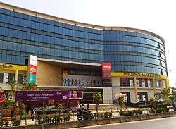
The area has witnessed a construction boom in the 21st century with the redevelopment of large former industrial plots. Kohinoor city and Phoenix Marketcity projects have been developed on land previously occupied by the Premier Automobiles and Mukand Engineering respectively .
New Kurla[]
The southern end of Kurla began developing with the arrival of the Cotton mills and the railway line. some prominent localities and landmarks are:
- Jai Bhawani Chowk, Jai Shankar Chowk and Subhash Nagar on New Mill Road. 90% people in Jai shankar Chowk are from Kaikadi Samaj and work in the BMC and Air India.
- BMC colony near New Mill Road & H.P. Keluskar Road.
- LIG, MIG and HIG Colonies at Vinobha Bhave Nagar which also has a police station by that name. Bhartiya Nagar, Gaurishankar Nagar located near the Premier Nalla are in its vicinity. The Santa Cruz – Chembur link road alignment passes through this area.
- K. B. Bhabha Hospital with its neighbourhoods of Chhadva Nagar and Murli Milan Society.
- Kurla Bus Depot on Lal Bahadur Shastri Marg (LBS Road) with the adjoining areas of Taximen's colony, Kapadia nagar and Kismat nagar on CST road. This area enjoys close proximity to the Bandra Kurla Complex.
- Kurla Railway Station area with the "Yadav Mandai" (Fish, Meat and Vegetable market )and the "L" ward municipal offices on Station Road and Brahminwadi on "Pipe Road" that runs along the water pipe line.
- Salafi Welfare Society near Halav pool, Gol Building and Masrani Lane.
- Indira Nagar, Parigh Khadi, and Kurla Garden are slum areas situated to the south of the Kurla Court
- Subash Nagar,located close to railway station on New Mill Road
Kurla East[]
areas in Kurla East include:
- Nehru Nagar: The Government Dairy is located here. It has Mumbai's second biggest MSRTC depot.
- Shriv Shrusti: A residential colony near the bus depot
- Railway Colony: A residential colony near Lokmanya Tilak Terminus
- Kamgar Nagar: A residential area with row houses (now developed as bungalows)
- Hilphi House (House of a Portuguese Builder)
Transport[]
Kurla is accessible from all parts of Mumbai by road and rail due to its central location.
Roads[]
The Lal Bahadur Shastri Marg (Formerly known as Old Agra Road) is the arterial road for Kurla West. The Road begins at the southern end of Salsette Island, passing through Kurla and continuing up north into Ghatkopar towards Thane. The Andheri – Kurla road links Kurla with Andheri via Saki Naka, while CST road leads to Santacruz. The Santa Cruz – Chembur link road which is under construction will bridge the east and west sides of Kurla. The Eastern Express Highway is the main thoroughfare for Kurla East. It runs from Sion Causeway in the south to Mulund in the North.
BEST buses ply from Kurla to all areas of Mumbai. The Kurla BEST Depot on the west suffered serious damage during the Mumbai floods of 2005 and has since been shut for redevelopment. Maharashtra State Transport buses ply from their depot at Nehru Nagar in the East to major towns in the State. Auto rickshaws and taxis are also available.
Railways[]
Kurla railway station is a junction of the Central Railway Suburban line and the Harbour Line.
Lokmanya Tilak Terminus, formerly known as Kurla Terminus situated in the East, handles several Central Railway Zone outstation trains everyday.