<p style="margin-top:0.5em;line-height:22.399999618530273px;color:rgb(37,37,37);font-family:sans-serif;">The '''Sahar Elevated Access Road''', abbreviated to '''SEAR''', is a dedicated, elevated, [http://en.wikipedia.org/wiki/Controlled-access_highway express] [http://en.wikipedia.org/wiki/Access_road access road] in [http://en.wikipedia.org/wiki/Mumbai Mumbai] that connects the [http://en.wikipedia.org/wiki/Western_Express_Highway Western Express Highway] (WEH) near Hanuman Nagar junction in [http://en.wikipedia.org/wiki/Vile_Parle Vile Parle], with the [http://en.wikipedia.org/wiki/Forecourt forecourts] of Terminal T2 of the [http://en.wikipedia.org/wiki/Chhatrapati_Shivaji_International_Airport Chhatrapati Shivaji International Airport]. It facilitates [[File:SEAR2.jpg|thumb|425px]]easier and quicker access to the commuters proceeding to and from the airport. The 2.2 km long access road has 4 entry and 2 exit points. The road also includes an underpass for vehicles travelling on the WEH and a pedestrian subway; as well as an underpass, a tunnel, and ramps connecting the highway to the terminal which bypasses the congested roadways below.</p>
+
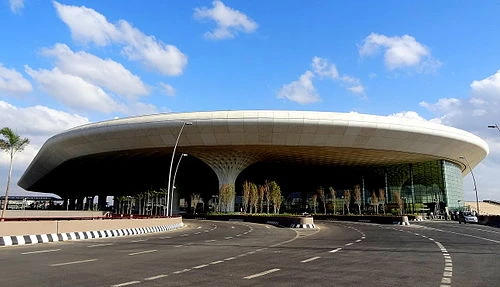
<p style="margin-top:0.5em;line-height:22.399999618530273px;color:rgb(37,37,37);font-family:sans-serif;">The '''Sahar Elevated Access Road''', abbreviated to '''SEAR''', is a dedicated, elevated, [http://en.wikipedia.org/wiki/Controlled-access_highway express] [http://en.wikipedia.org/wiki/Access_road access road] in [http://en.wikipedia.org/wiki/Mumbai Mumbai] that connects the [http://en.wikipedia.org/wiki/Western_Express_Highway Western Express Highway] (WEH) near Hanuman Nagar junction in [http://en.wikipedia.org/wiki/Vile_Parle Vile Parle], with the [http://en.wikipedia.org/wiki/Forecourt forecourts] of Terminal T2 of the [http://en.wikipedia.org/wiki/Chhatrapati_Shivaji_International_Airport Chhatrapati Shivaji International Airport]. It facilitates [[File:MumbaiAirportT2.jpg|thumb|400px]]easier and quicker access to the commuters proceeding to and from the airport. The 2.2 km long access road has 4 entry and 2 exit points. The road also includes an underpass for vehicles travelling on the WEH and a pedestrian subway; as well as an underpass, a tunnel, and ramps connecting the highway to the terminal which bypasses the congested roadways below.</p>
<p style="margin-top:0.5em;margin-bottom:0.5em;line-height:22.399999618530273px;color:rgb(37,37,37);font-family:sans-serif;">The corridor was developed by the [http://en.wikipedia.org/wiki/Mumbai_Metropolitan_Region_Development_Authority Mumbai Metropolitan Region Development Authority] (MMRDA) under its Mumbai Urban Infrastructure Project (MUIP). The project cost of <span class="nowrap" style="white-space:nowrap;">[http://en.wikipedia.org/wiki/Indian_rupee]400.77 [http://en.wikipedia.org/wiki/Crore crore]</span> (US$67 million), approved by the [http://en.wikipedia.org/wiki/Jawaharlal_Nehru_National_Urban_Renewal_Mission Jawaharlal Nehru National Urban Renewal Mission] (JnNURM), was paid by the [http://en.wikipedia.org/wiki/Government_of_India Central Government], the [http://en.wikipedia.org/wiki/Government_of_Maharashtra Government of Maharashtra], the MMRDA, and the [http://en.wikipedia.org/wiki/Chhatrapati_Shivaji_International_Airport Mumbai International Airport Limited] (MIAL).</p>
<p style="margin-top:0.5em;margin-bottom:0.5em;line-height:22.399999618530273px;color:rgb(37,37,37);font-family:sans-serif;">The corridor was developed by the [http://en.wikipedia.org/wiki/Mumbai_Metropolitan_Region_Development_Authority Mumbai Metropolitan Region Development Authority] (MMRDA) under its Mumbai Urban Infrastructure Project (MUIP). The project cost of <span class="nowrap" style="white-space:nowrap;">[http://en.wikipedia.org/wiki/Indian_rupee]400.77 [http://en.wikipedia.org/wiki/Crore crore]</span> (US$67 million), approved by the [http://en.wikipedia.org/wiki/Jawaharlal_Nehru_National_Urban_Renewal_Mission Jawaharlal Nehru National Urban Renewal Mission] (JnNURM), was paid by the [http://en.wikipedia.org/wiki/Government_of_India Central Government], the [http://en.wikipedia.org/wiki/Government_of_Maharashtra Government of Maharashtra], the MMRDA, and the [http://en.wikipedia.org/wiki/Chhatrapati_Shivaji_International_Airport Mumbai International Airport Limited] (MIAL).</p>
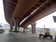
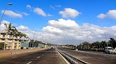
[[File:SEAR2.jpg|thumb|425px]]<p style="margin-top:0.5em;line-height:22.399999618530273px;color:rgb(37,37,37);font-family:sans-serif;">The six-lane, signal-free approach road originates near Hanuman Nagar junction in Vile Parle on the Western Express Highway (WEH), and ends at </p><p style="margin-top:0.5em;line-height:22.399999618530273px;color:rgb(37,37,37);font-family:sans-serif;">the [http://en.wikipedia.org/wiki/Forecourt forecourts] of Terminal T2 of the [http://en.wikipedia.org/wiki/Chhatrapati_Shivaji_International_Airport Chhatrapati Shivaji International Airport]. From the WEH, the road heads east till the elevated section takes it over the Sahar Road. The corridor continues east over the Indian Airlines Project Road till it reaches the current main approach of the International terminal, wh</p><p style="margin-top:0.5em;line-height:22.399999618530273px;color:rgb(37,37,37);font-family:sans-serif;">ere the corridor disperses into ramps which lead to the arrival and departure of the Terminal forecourts. The road has two lanes on either side joining the elevated road from southern and northern side. Three lanes from Terminal 2 open towards the southern and northern side through the WEH. The bridge deck has planters on either side for plantation of palm trees and shrubs, to give motorists a pleasant driving experience. The road has six lanes apart from space for plantations and maintenance areas.</p>
+
<p style="margin-top:0.5em;margin-bottom:0.5em;line-height:22.399999618530273px;color:rgb(37,37,37);font-family:sans-serif;">The signal free road is 2.2 km long and 27.5 m wide, providing 3 lanes each for up and down traffic. On the WEH end, the project comprises 1,050 metres (3,440 ft) of elevated road, a 98-metre-long (322 ft) tunnel with ramps measuring 261 metres (856 ft), three vehicular underpasses each at 48, 22, and</p>
−
[http://en.wikipedia.org/wiki/File:SEAR5.JPG]View of SEAR
−
[http://en.wikipedia.org/wiki/File:SEAR4.JPG]View of SEAR
−
[http://en.wikipedia.org/wiki/File:SEAR3.JPG]View of SEAR
−
[http://en.wikipedia.org/wiki/File:SEAR2.JPG]Exit from Western Exress Highway
[http://en.wikipedia.org/wiki/File:SEAR3InsideTunnel.JPG]SEAR Inside Tunnel View<p style="margin-top:0.5em;line-height:22.399999618530273px;color:rgb(37,37,37);font-family:sans-serif;">The six-lane, signal-free approach road originates near Hanuman Nagar junction in Vile Parle on the Western Express Highway (WEH), and ends at the [http://en.wikipedia.org/wiki/Forecourt forecourts] of Terminal T2 of the [http://en.wikipedia.org/wiki/Chhatrapati_Shivaji_International_Airport Chhatrapati Shivaji International Airport]. From the WEH, the road heads east till the elevated section takes it over the Sahar Road. The corridor continues east over the Indian Airlines Project Road till it reaches the current main approach of the International terminal, where the corridor disperses into ramps which lead to the arrival and departure of the Terminal forecourts. The road has two lanes on either side joining the elevated road from southern and northern side. Three lanes from Terminal 2 open towards the southern and northern side through the WEH. The bridge deck has planters on either side for plantation of palm trees and shrubs, to give motorists a pleasant driving experience. The road has six lanes apart from space for plantations and maintenance areas.</p>
−
<p style="margin-top:0.5em;margin-bottom:0.5em;line-height:22.399999618530273px;color:rgb(37,37,37);font-family:sans-serif;">The signal free road is 2.2 km long and 27.5 m wide, providing 3 lanes each for up and down traffic. On the WEH end, the project comprises 1,050 metres (3,440 ft) of elevated road, a 98-metre-long (322 ft) tunnel with ramps measuring 261 metres (856 ft), three vehicular underpasses each at 48, 22, and 30 metres (157, 72, and 98 ft), and 641 metres (2,103 ft) of six-lane at-grade roadway. The plan also includes a 48-metre (157 ft) pedestrian underpass on the WEH. The road will also have four ramps measuring 2,200 metres (7,200 ft) on the airport end.</p>
+
<p style="margin-top:0.5em;margin-bottom:0.5em;line-height:22.399999618530273px;color:rgb(37,37,37);font-family:sans-serif;">30 metres (157, 72, and 98 ft), and 641 metres (2,103 ft) of six-lane at-grade roadway. The plan also includes a 48-metre (157 ft) pedestrian underpass on the WEH. The road will also have four ramps measuring 2,200 metres (7,200 ft) on the airport end.</p>
<p style="margin-top:0.5em;margin-bottom:0.5em;line-height:22.399999618530273px;color:rgb(37,37,37);font-family:sans-serif;">The road allows motorists to traverse the distance of 4–5 km from the highway to the airport in five minutes instead of the 30–45 minutes it took prior to its opening.</p>
<p style="margin-top:0.5em;margin-bottom:0.5em;line-height:22.399999618530273px;color:rgb(37,37,37);font-family:sans-serif;">The road allows motorists to traverse the distance of 4–5 km from the highway to the airport in five minutes instead of the 30–45 minutes it took prior to its opening.</p>
==History==
==History==
+
−
===Background===
+
==='''Background[[File:SEAR5.jpg|thumb]]'''===
<p style="margin-top:0.5em;line-height:22.399999618530273px;color:rgb(37,37,37);font-family:sans-serif;">Despite the proposed Terminal 2's proximity with Mumbai's arterial [http://en.wikipedia.org/wiki/Western_Express_Highway Western Express Highway], commuters approaching the terminal had to travel via the congested roads of eastern [http://en.wikipedia.org/wiki/Andheri Andheri](viz. Sahar Road) before reaching the airport's forecourt. Commuters had to cross cross Sambhaji Nagar, Rajaram Wadi, NAD Colony, Dr Babasaheb Ambedkar Road, Bamanwada, Sahar Post and Telegraph Colony, GVK Residential Colony and slow-moving traffic on Sahar road to reach the international terminal. The approximately 4–5 km route required about 40–45 minutes to traverse.</p>
<p style="margin-top:0.5em;line-height:22.399999618530273px;color:rgb(37,37,37);font-family:sans-serif;">Despite the proposed Terminal 2's proximity with Mumbai's arterial [http://en.wikipedia.org/wiki/Western_Express_Highway Western Express Highway], commuters approaching the terminal had to travel via the congested roads of eastern [http://en.wikipedia.org/wiki/Andheri Andheri](viz. Sahar Road) before reaching the airport's forecourt. Commuters had to cross cross Sambhaji Nagar, Rajaram Wadi, NAD Colony, Dr Babasaheb Ambedkar Road, Bamanwada, Sahar Post and Telegraph Colony, GVK Residential Colony and slow-moving traffic on Sahar road to reach the international terminal. The approximately 4–5 km route required about 40–45 minutes to traverse.</p>
<p style="margin-top:0.5em;margin-bottom:0.5em;line-height:22.399999618530273px;color:rgb(37,37,37);font-family:sans-serif;">The impending shift of domestic air traffic would also make the situation worse during the daytime and the evening-peak traffic hours. To avoid these traffic bottlenecks, an elevated direct corridor by-passing the crowded [http://en.wikipedia.org/wiki/Chakala Chakala], [http://en.wikipedia.org/wiki/Sahar,_Maharashtra Sahar] Road, and the Jog flyover areas of Andheri (East) was envisioned. The elevated road was constructed to provide direct access to the international terminal, and to provide fliers with an easy and quicker access to the airport. as well as ease traffic congestion on the WEH, more importantly at the Andheri-Kurla road junction. The SEAR had a tunnel incorporated into the design; it enables motorists on the WEH to access the SEAR with ease.</p>
<p style="margin-top:0.5em;margin-bottom:0.5em;line-height:22.399999618530273px;color:rgb(37,37,37);font-family:sans-serif;">The impending shift of domestic air traffic would also make the situation worse during the daytime and the evening-peak traffic hours. To avoid these traffic bottlenecks, an elevated direct corridor by-passing the crowded [http://en.wikipedia.org/wiki/Chakala Chakala], [http://en.wikipedia.org/wiki/Sahar,_Maharashtra Sahar] Road, and the Jog flyover areas of Andheri (East) was envisioned. The elevated road was constructed to provide direct access to the international terminal, and to provide fliers with an easy and quicker access to the airport. as well as ease traffic congestion on the WEH, more importantly at the Andheri-Kurla road junction. The SEAR had a tunnel incorporated into the design; it enables motorists on the WEH to access the SEAR with ease.</p>
<p style="margin-top:0.5em;line-height:22.399999618530273px;color:rgb(37,37,37);font-family:sans-serif;">The project was commissioned in January 2008, and the original deadline for completing the entire project was January 2010. The 1300 metre elevated portion of the road was completed as per schedule. However, the remaining portion of the project was delayed and missed several deadlines. According to the [http://en.wikipedia.org/wiki/Mumbai_Metropolitan_Region_Development_Authority Mumbai Metropolitan Region Development Authority] (MMRDA), the main reason for the delay in commissioning the project was the rehabilitation of 700 residents.</p>
−
−
[http://en.wikipedia.org/wiki/File:Sahar_Elevated_Access_Road_under_construction_2.jpg]The Sahar Elevated Access Road under construction.
[http://en.wikipedia.org/wiki/File:Sahar_Elevated_Access_Road_under_construction_3.jpg]The Sahar Elevated Access Road under construction.<p style="margin-top:0.5em;line-height:22.399999618530273px;color:rgb(37,37,37);font-family:sans-serif;">The project was commissioned in January 2008, and the original deadline for completing the entire project was January 2010.<sup class="reference" id="cite_ref-dnaindia1_9-4" style="line-height:1;unicode-bidi:-webkit-isolate;">[http://en.wikipedia.org/wiki/Sahar_Elevated_Access_Road#cite_note-dnaindia1-9 [9]]</sup> The 1300 metre elevated portion of the road was completed as per schedule. However, the remaining portion of the project was delayed and missed several deadlines. According to the [http://en.wikipedia.org/wiki/Mumbai_Metropolitan_Region_Development_Authority Mumbai Metropolitan Region Development Authority] (MMRDA), the main reason for the delay in commissioning the project was the rehabilitation of 700 residents.<sup class="reference" id="cite_ref-indiatimes1_2-3" style="line-height:1;unicode-bidi:-webkit-isolate;">[http://en.wikipedia.org/wiki/Sahar_Elevated_Access_Road#cite_note-indiatimes1-2 [2]]</sup></p>
−
<p style="margin-top:0.5em;margin-bottom:0.5em;line-height:22.399999618530273px;color:rgb(37,37,37);font-family:sans-serif;">The corridor was developed by the MMRDA under its Mumbai Urban Infrastructure Project (MUIP) scheme with [http://en.wikipedia.org/wiki/Jawaharlal_Nehru_National_Urban_Renewal_Mission Jawaharlal Nehru National Urban Renewal Mission] (JnNURM) funding. The project was funded by the [http://en.wikipedia.org/wiki/Government_of_India Central Government], the [http://en.wikipedia.org/wiki/Government_of_Maharashtra State Government], the MMRDA, and the [http://en.wikipedia.org/wiki/Chhatrapati_Shivaji_International_Airport Mumbai International Airport Limited] (MIAL). The Sahar Elevated Access Road was constructed jointly by the MMRDA and the MIAL.<sup class="reference" id="cite_ref-dnaindia2_10-1" style="line-height:1;unicode-bidi:-webkit-isolate;">[http://en.wikipedia.org/wiki/Sahar_Elevated_Access_Road#cite_note-dnaindia2-10 [10]]</sup> The cost of construction for the MMRDA was <span class="nowrap" style="white-space:nowrap;">[http://en.wikipedia.org/wiki/Indian_rupee]377.59 [http://en.wikipedia.org/wiki/Crore crore]</span> (US$63 million), higher than the earlier estimated <span class="nowrap" style="white-space:nowrap;">[http://en.wikipedia.org/wiki/Indian_rupee]287.37 [http://en.wikipedia.org/wiki/Crore crore]</span>(US$48 million). The road was built in two parts: the first was a 1.8 km stretch from the WEH to the Hyatt Regency (on Sahar Airport Road), and the second was a 1.5 km stretch from the Hyatt Regency to the airport. The first section cost <span class="nowrap" style="white-space:nowrap;">[http://en.wikipedia.org/wiki/Indian_rupee]3.43 billion</span> (US$57 million) and was built by the MMRDA, while the second cost <span class="nowrap" style="white-space:nowrap;">[http://en.wikipedia.org/wiki/Indian_rupee]2.27 billion</span> (US$38 million) and was built by MIAL.</p>
+
<p style="margin-top:0.5em;margin-bottom:0.5em;line-height:22.399999618530273px;color:rgb(37,37,37);font-family:sans-serif;">The corridor was developed by the MMRDA under its Mumbai Urban Infrastructure Project (MUIP) scheme with [http://en.wikipedia.org/wiki/Jawaharlal_Nehru_National_Urban_Renewal_Mission Jawaharlal Nehru National Urban Renewal Mission] (JnNURM) funding. The project was funded by the [http://en.wikipedia.org/wiki/Government_of_India Central Government], the [http://en.wikipedia.org/wiki/Government_of_Maharashtra State Government], the MMRDA, and the [http://en.wikipedia.org/wiki/Chhatrapati_Shivaji_International_Airport Mumbai International Airport Limited] (MIAL). The Sahar Elevated Access Road was constructed jointly by the MMRDA and the MIAL. The cost of construction for the MMRDA was <span class="nowrap" style="white-space:nowrap;">377.59 [http://en.wikipedia.org/wiki/Crore crore]</span> (US$63 million), higher than the earlier estimated <span class="nowrap" style="white-space:nowrap;">287.37 [http://en.wikipedia.org/wiki/Crore crore]</span>(US$48 million). The road was built in two parts: the first was a 1.8 km stretch from the WEH to the Hyatt Regency (on Sahar Airport Road), and the second was a 1.5 km stretch from the Hyatt Regency to the airport. The first section cost <span class="nowrap" style="white-space:nowrap;">3.43 billion</span> (US$57 million) and was built by the MMRDA, while the second cost <span class="nowrap" style="white-space:nowrap;">2.27 billion</span> (US$38 million) and was built by MIAL.</p>
−
<p style="margin-top:0.5em;margin-bottom:0.5em;line-height:22.399999618530273px;color:rgb(37,37,37);font-family:sans-serif;">The 1,300 metre long elevated road consists of 30 spans of 35-metre-long (115 ft) precast concrete segments erected using a specially fabricated launching girder and strand jack. The pillars measure 2.5 by 2.8 metres (8.2 ft × 9.2 ft) at the base. The 27.6-metre (91 ft) deck superstructure is composed of a 9-metre-wide (30 ft) precast central spine and two 9.3-metre (31 ft) cantilever wings on either side connected to the central spine by concrete stitching and transverse pre-stressing methods.The pedestrian, and two and three-wheeler underpasses on the Western Express Highway were constructed with pre-cast box cells. The approaches on either sides were built with reinforced earth walls. The pedestrian and vehicular underpass on Western Express Highway in Vile Parle is 45 metres long, and the MIAL underpass on Justice MC Chhagla Road is 48 metres long. A 98.5-metre-long (323 ft) tunnel was constructed at the junction of the corridor with the WEH using the cut and cover method with concrete contiguous piles. This is the city's first vehicular underpass built with cut-and-cover technology. It has 26.2 metre long ramps on either side of the WEH for the traffic coming from the southern side and going to the international airport.</p>
+
<p style="margin-top:0.5em;margin-bottom:0.5em;line-height:22.399999618530273px;color:rgb(37,37,37);font-family:sans-serif;">The 1,300 metre long elevated road consists of 30 spans of 35-metre-long (115 ft) precast concrete segments erected using a specially fabricated launching girder and strand jack. The pillars measure 2.5 by 2.8 metres (8.2 ft × 9.2 ft) at the base. The 27.6-metre (91 ft) deck superstructure is composed of a 9-[[File:SEAR3.jpg|thumb]]metre-wide (30 ft) precast central spine and two 9.3-metre (31 ft) cantilever wings on either side connected to the central spine by concrete stitching and transverse pre-stressing methods.The pedestrian, and two and three-wheeler underpasses on the Western Express Highway were constructed with pre-cast box cells. The approaches on either sides were built with reinforced earth walls. The pedestrian and vehicular underpass on Western Express Highway in Vile Parle is 45 metres long, and the MIAL underpass on Justice MC Chhagla Road is 48 metres long. A 98.5-metre-long (323 ft) tunnel was constructed at the junction of the corridor with the WEH using the cut and cover method with concrete contiguous piles. This is the city's first vehicular underpass built with cut-and-cover technology. It has 26.2 metre long ramps on either side of the WEH for the traffic coming from the southern side and going to the international airport.</p>
<p style="margin-top:0.5em;margin-bottom:0.5em;line-height:22.399999618530273px;color:rgb(37,37,37);font-family:sans-serif;">The elevated corridor is the only corridor in the India to be built on one pone with spines (the structure is called as the fish belly structure).The Sahar Elevated Access Road is the widest deck in India on a single pier. The bridge deck of 27.5 meters width consists of a central spine segment 9 metres wide, and cantilever segments of 9 meters each of either side with transverse pre-stressing technology, which is rare in India. The freeway has no traffic signals or intersections, and has been designed for motorists to accelerate at a speed of up to 100kmph.</p>
<p style="margin-top:0.5em;margin-bottom:0.5em;line-height:22.399999618530273px;color:rgb(37,37,37);font-family:sans-serif;">The elevated corridor is the only corridor in the India to be built on one pone with spines (the structure is called as the fish belly structure).The Sahar Elevated Access Road is the widest deck in India on a single pier. The bridge deck of 27.5 meters width consists of a central spine segment 9 metres wide, and cantilever segments of 9 meters each of either side with transverse pre-stressing technology, which is rare in India. The freeway has no traffic signals or intersections, and has been designed for motorists to accelerate at a speed of up to 100kmph.</p>
Line 39:
Line 35:
<p style="margin-top:0.5em;margin-bottom:0.5em;line-height:22.399999618530273px;color:rgb(37,37,37);font-family:sans-serif;">The Sahar Elevated Access Road was inaugurated by Chief Minister Prithviraj Chavan on 12 February 2014, and was opened to the public from 2pm on the same day. The new terminal at [http://en.wikipedia.org/wiki/BOM BOM] opened to air traffic on the same day.</p>
<p style="margin-top:0.5em;margin-bottom:0.5em;line-height:22.399999618530273px;color:rgb(37,37,37);font-family:sans-serif;">The Sahar Elevated Access Road was inaugurated by Chief Minister Prithviraj Chavan on 12 February 2014, and was opened to the public from 2pm on the same day. The new terminal at [http://en.wikipedia.org/wiki/BOM BOM] opened to air traffic on the same day.</p>
====Impediments====
====Impediments====
−
<p style="margin-top:0.5em;line-height:22.399999618530273px;color:rgb(37,37,37);font-family:sans-serif;">The construction of the Sahar Elevated Access Road faced impediments such as resettlement and rehabilitation of project affected families, non-availability of land from various government departments, difficulties in diverting traffic, as well as shifting and relaying various underground utilities. Construction could also only be carried out during restricted working hours owing to the close proximity of the construction site with the runway. Carrying out these construction activities on one of Mumbai’s busiest roads, with minimum interference to traffic, was a major challenge. There was no opportunity for diversion of traffic as the deck-width of the bridge was as wide as the road-width below. Frequent VIP movements accessing the airport further compounded the problem. Also, the corridor passes by the Post & Telegraph colony and a few 5-star hotels which were apprehensive about the project. The issues were sorted through negotiations and environmentally friendly construction practices.</p>
+
<p style="margin-top:0.5em;line-height:22.399999618530273px;color:rgb(37,37,37);font-family:sans-serif;">The construction of the Sahar Elevated Access Road faced impediments such as resettlement and rehabilitation of project affected families, non-availability [[File:SEAR.jpg|thumb]]of land from various government departments, difficulties in diverting traffic, as well as shifting and relaying various underground utilities. Construction could also only be carried out during restricted working hours owing to the close proximity of the construction site with the runway. Carrying out these construction activities on one of Mumbai’s busiest roads, with minimum interference to traffic, was a major challenge. There was no opportun</p>
+
<p style="margin-top:0.5em;line-height:22.399999618530273px;color:rgb(37,37,37);font-family:sans-serif;">ity for diversion of traffic as the deck-width of the bridge was as wide as the road-width below. Frequent VIP movements accessing the airport further compounded the problem. Also, the corridor passes by the Post & Telegraph colony and a few 5-star hotels which were apprehensive about the project. The issues were sorted through negotiations and environmentally friendly construction practices.</p>
<p style="margin-top:0.5em;margin-bottom:0.5em;line-height:22.399999618530273px;color:rgb(37,37,37);font-family:sans-serif;">The work on the tunnel at the Western Express Highway end of the corridor was carried out only at night because the location lies within the landing and taking off ''funnel'' of the adjacent airport runway. Work at the site was halted several times by the airport authorities due to emergency landings on the runway. Space constraints at the casting yard were dealt with by designing the pre-cast and cantilever segments so they could be stacked in two piers. The pedestrian and vehicular underpasses on the WEH were constructed in planned phases to minimize disturbance to traffic, allowing completion of the project in record time.</p>
<p style="margin-top:0.5em;margin-bottom:0.5em;line-height:22.399999618530273px;color:rgb(37,37,37);font-family:sans-serif;">The work on the tunnel at the Western Express Highway end of the corridor was carried out only at night because the location lies within the landing and taking off ''funnel'' of the adjacent airport runway. Work at the site was halted several times by the airport authorities due to emergency landings on the runway. Space constraints at the casting yard were dealt with by designing the pre-cast and cantilever segments so they could be stacked in two piers. The pedestrian and vehicular underpasses on the WEH were constructed in planned phases to minimize disturbance to traffic, allowing completion of the project in record time.</p>
−
<p style="margin-top:0.5em;margin-bottom:0.5em;line-height:22.399999618530273px;color:rgb(37,37,37);font-family:sans-serif;">700 project-affected persons (PAPs), residents of Baman Vada, Ambedkar Nagar and Rajaram Wadi near the Western Express Highway, were to be rehabilitated at the [http://en.wikipedia.org/wiki/Kurla Kurla] site of Housing Development and Infrastructure Limited (HDIL) in accordance with the existing rehabilitation policy of MMRDA. The rehabilitation was to be done by MIAL through HDIL and MMRDA as a co-ordinating agency. Work on the project had been delayed as many PAPs living along the route had initially refused to shift to resettlement colonies in [http://en.wikipedia.org/wiki/Kurla Kurla] and [http://en.wikipedia.org/wiki/Oshiwara Oshiwara]. They agreed to shift after prolonged negotiations with the MMRDA. Many slum dwellers were technically not eligible for rehabilitation. The correspondence between PAPs and MMRDA delayed the demolition of these houses. According to local MLA Krishna Hegde, 750 houses were shifted for to construct the flyover and 250 houses, though ineligible, were given alternate housing. Among the relocated were 70 shops of marble traders.</p>
+
<p style="margin-top:0.5em;margin-bottom:0.5em;line-height:22.399999618530273px;color:rgb(37,37,37);font-family:sans-serif;">700 project-affected persons (PAPs), residents of Baman Vada, Ambedkar Nagar and Rajaram Wadi near the Western Express Highway, were to be [[File:SEAR2_(1).jpg|thumb]]rehabilitated at the [http://en.wikipedia.org/wiki/Kurla Kurla] site of Housing Development and Infrastructure Limited (HDIL) in accordance with the existing rehabilitation policy of MMRDA. The rehabilitation was to be done by MIAL through HDIL and MMRDA as a co-ordinating agency. Work on the project had been delayed as many PAPs living along the route had initially refused to shift to resettlement colonies in [http://en.wikipedia.org/wiki/Kurla Kurla] and [http://en.wikipedia.org/wiki/Oshiwara Oshiwara]. They agreed to shift after prolonged negotiations with the MMRDA. Many slum dwellers were technically not eligible for rehabilitation. The correspondence between PAPs and MMRDA delayed the demolition of these houses. According to local MLA Krishna Hegde, 750 houses were shifted for to construct the flyover and 250 houses, though ineligible, were given alternate housing. Among the relocated were 70 shops of marble traders.</p>
easier and quicker access to the commuters proceeding to and from the airport. The 2.2 km long access road has 4 entry and 2 exit points. The road also includes an underpass for vehicles travelling on the WEH and a pedestrian subway; as well as an underpass, a tunnel, and ramps connecting the highway to the terminal which bypasses the congested roadways below.
Only four-wheelers and private buses are permitted to use the Sahar Elevated Road. Three-wheelers, two-wheelers and BEST buses are not permitted on the road, and must use the existing road to access the Terminal 2 building.
The six-lane, signal-free approach road originates near Hanuman Nagar junction in Vile Parle on the Western Express Highway (WEH), and ends at
the forecourts of Terminal T2 of the Chhatrapati Shivaji International Airport. From the WEH, the road heads east till the elevated section takes it over the Sahar Road. The corridor continues east over the Indian Airlines Project Road till it reaches the current main approach of the International terminal, wh
ere the corridor disperses into ramps which lead to the arrival and departure of the Terminal forecourts. The road has two lanes on either side joining the elevated road from southern and northern side. Three lanes from Terminal 2 open towards the southern and northern side through the WEH. The bridge deck has planters on either side for plantation of palm trees and shrubs, to give motorists a pleasant driving experience. The road has six lanes apart from space for plantations and maintenance areas.
The signal free road is 2.2 km long and 27.5 m wide, providing 3 lanes each for up and down traffic. On the WEH end, the project comprises 1,050 metres (3,440 ft) of elevated road, a 98-metre-long (322 ft) tunnel with ramps measuring 261 metres (856 ft), three vehicular underpasses each at 48, 22, and
30 metres (157, 72, and 98 ft), and 641 metres (2,103 ft) of six-lane at-grade roadway. The plan also includes a 48-metre (157 ft) pedestrian underpass on the WEH. The road will also have four ramps measuring 2,200 metres (7,200 ft) on the airport end.
The road allows motorists to traverse the distance of 4–5 km from the highway to the airport in five minutes instead of the 30–45 minutes it took prior to its opening.
History
Background
Despite the proposed Terminal 2's proximity with Mumbai's arterial Western Express Highway, commuters approaching the terminal had to travel via the congested roads of eastern Andheri(viz. Sahar Road) before reaching the airport's forecourt. Commuters had to cross cross Sambhaji Nagar, Rajaram Wadi, NAD Colony, Dr Babasaheb Ambedkar Road, Bamanwada, Sahar Post and Telegraph Colony, GVK Residential Colony and slow-moving traffic on Sahar road to reach the international terminal. The approximately 4–5 km route required about 40–45 minutes to traverse.
The impending shift of domestic air traffic would also make the situation worse during the daytime and the evening-peak traffic hours. To avoid these traffic bottlenecks, an elevated direct corridor by-passing the crowded Chakala, Sahar Road, and the Jog flyover areas of Andheri (East) was envisioned. The elevated road was constructed to provide direct access to the international terminal, and to provide fliers with an easy and quicker access to the airport. as well as ease traffic congestion on the WEH, more importantly at the Andheri-Kurla road junction. The SEAR had a tunnel incorporated into the design; it enables motorists on the WEH to access the SEAR with ease.
Construction
The project was commissioned in January 2008, and the original deadline for completing the entire project was January 2010. The 1300 metre elevated portion of the road was completed as per schedule. However, the remaining portion of the project was delayed and missed several deadlines. According to the Mumbai Metropolitan Region Development Authority (MMRDA), the main reason for the delay in commissioning the project was the rehabilitation of 700 residents.
The corridor was developed by the MMRDA under its Mumbai Urban Infrastructure Project (MUIP) scheme with Jawaharlal Nehru National Urban Renewal Mission (JnNURM) funding. The project was funded by the Central Government, the State Government, the MMRDA, and the Mumbai International Airport Limited (MIAL). The Sahar Elevated Access Road was constructed jointly by the MMRDA and the MIAL. The cost of construction for the MMRDA was 377.59 crore (US$63 million), higher than the earlier estimated 287.37 crore(US$48 million). The road was built in two parts: the first was a 1.8 km stretch from the WEH to the Hyatt Regency (on Sahar Airport Road), and the second was a 1.5 km stretch from the Hyatt Regency to the airport. The first section cost 3.43 billion (US$57 million) and was built by the MMRDA, while the second cost 2.27 billion (US$38 million) and was built by MIAL.
The 1,300 metre long elevated road consists of 30 spans of 35-metre-long (115 ft) precast concrete segments erected using a specially fabricated launching girder and strand jack. The pillars measure 2.5 by 2.8 metres (8.2 ft × 9.2 ft) at the base. The 27.6-metre (91 ft) deck superstructure is composed of a 9-
metre-wide (30 ft) precast central spine and two 9.3-metre (31 ft) cantilever wings on either side connected to the central spine by concrete stitching and transverse pre-stressing methods.The pedestrian, and two and three-wheeler underpasses on the Western Express Highway were constructed with pre-cast box cells. The approaches on either sides were built with reinforced earth walls. The pedestrian and vehicular underpass on Western Express Highway in Vile Parle is 45 metres long, and the MIAL underpass on Justice MC Chhagla Road is 48 metres long. A 98.5-metre-long (323 ft) tunnel was constructed at the junction of the corridor with the WEH using the cut and cover method with concrete contiguous piles. This is the city's first vehicular underpass built with cut-and-cover technology. It has 26.2 metre long ramps on either side of the WEH for the traffic coming from the southern side and going to the international airport.
The elevated corridor is the only corridor in the India to be built on one pone with spines (the structure is called as the fish belly structure).The Sahar Elevated Access Road is the widest deck in India on a single pier. The bridge deck of 27.5 meters width consists of a central spine segment 9 metres wide, and cantilever segments of 9 meters each of either side with transverse pre-stressing technology, which is rare in India. The freeway has no traffic signals or intersections, and has been designed for motorists to accelerate at a speed of up to 100kmph.
The Sahar Elevated Access Road was inaugurated by Chief Minister Prithviraj Chavan on 12 February 2014, and was opened to the public from 2pm on the same day. The new terminal at BOM opened to air traffic on the same day.
Impediments
The construction of the Sahar Elevated Access Road faced impediments such as resettlement and rehabilitation of project affected families, non-availability
of land from various government departments, difficulties in diverting traffic, as well as shifting and relaying various underground utilities. Construction could also only be carried out during restricted working hours owing to the close proximity of the construction site with the runway. Carrying out these construction activities on one of Mumbai’s busiest roads, with minimum interference to traffic, was a major challenge. There was no opportun
ity for diversion of traffic as the deck-width of the bridge was as wide as the road-width below. Frequent VIP movements accessing the airport further compounded the problem. Also, the corridor passes by the Post & Telegraph colony and a few 5-star hotels which were apprehensive about the project. The issues were sorted through negotiations and environmentally friendly construction practices.
The work on the tunnel at the Western Express Highway end of the corridor was carried out only at night because the location lies within the landing and taking off funnel of the adjacent airport runway. Work at the site was halted several times by the airport authorities due to emergency landings on the runway. Space constraints at the casting yard were dealt with by designing the pre-cast and cantilever segments so they could be stacked in two piers. The pedestrian and vehicular underpasses on the WEH were constructed in planned phases to minimize disturbance to traffic, allowing completion of the project in record time.
700 project-affected persons (PAPs), residents of Baman Vada, Ambedkar Nagar and Rajaram Wadi near the Western Express Highway, were to be
rehabilitated at the Kurla site of Housing Development and Infrastructure Limited (HDIL) in accordance with the existing rehabilitation policy of MMRDA. The rehabilitation was to be done by MIAL through HDIL and MMRDA as a co-ordinating agency. Work on the project had been delayed as many PAPs living along the route had initially refused to shift to resettlement colonies in Kurla and Oshiwara. They agreed to shift after prolonged negotiations with the MMRDA. Many slum dwellers were technically not eligible for rehabilitation. The correspondence between PAPs and MMRDA delayed the demolition of these houses. According to local MLA Krishna Hegde, 750 houses were shifted for to construct the flyover and 250 houses, though ineligible, were given alternate housing. Among the relocated were 70 shops of marble traders.


.jpg)